
CMOR NEX GEN South Atlantic V2 COMPLETE MARINE VIEW


CMOR NEX GEN South Atlantic V2 COMPLETE MARINE VIEW
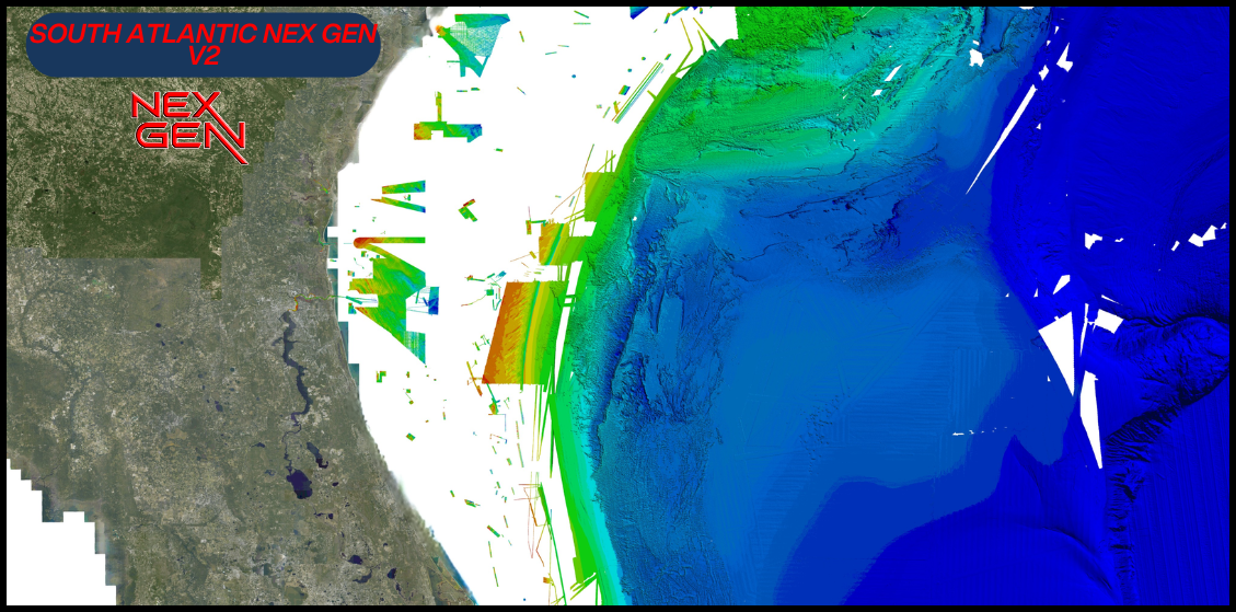
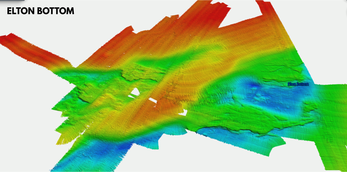
CMOR NEX GEN South Atlantic V2 COMPLETE MARINE VIEW a massive expansion of private data along with a full navigation chart throughout the coast and covers of some of the best fishing, diving, and deep dropping spots in the Atlantic Ocean. This chart has coverage from Stuart Florida up through South Carolina. Release Date 3/24/26.
CMOR NEX GEN transcends traditional mapping by combining ultra-high resolution bathymetric imagery with full navigational data and aerial imagery — so whether you’re fishing, diving, or safe-navigating, everything you need is visible at a glance.
Visualize wrecks, reefs, artificial structure, and bottom contours while simultaneously seeing buoys, speed routes, bridges, and marinas — all tied in with the latest aerial imagery of shorelines and shallow water.
All CMOR Cards with the exception of Furuno are provided on Micro SD cards with a standard SD adapter included.
Furuno customers: Instead of a physical card, you will receive an unlock code to access CMOR imagery on your device. Your NavNet system ID is required in order to generate the unlock code. Also, please note that South Atlantic is not yet available for Furuno is it is in the processing stage.
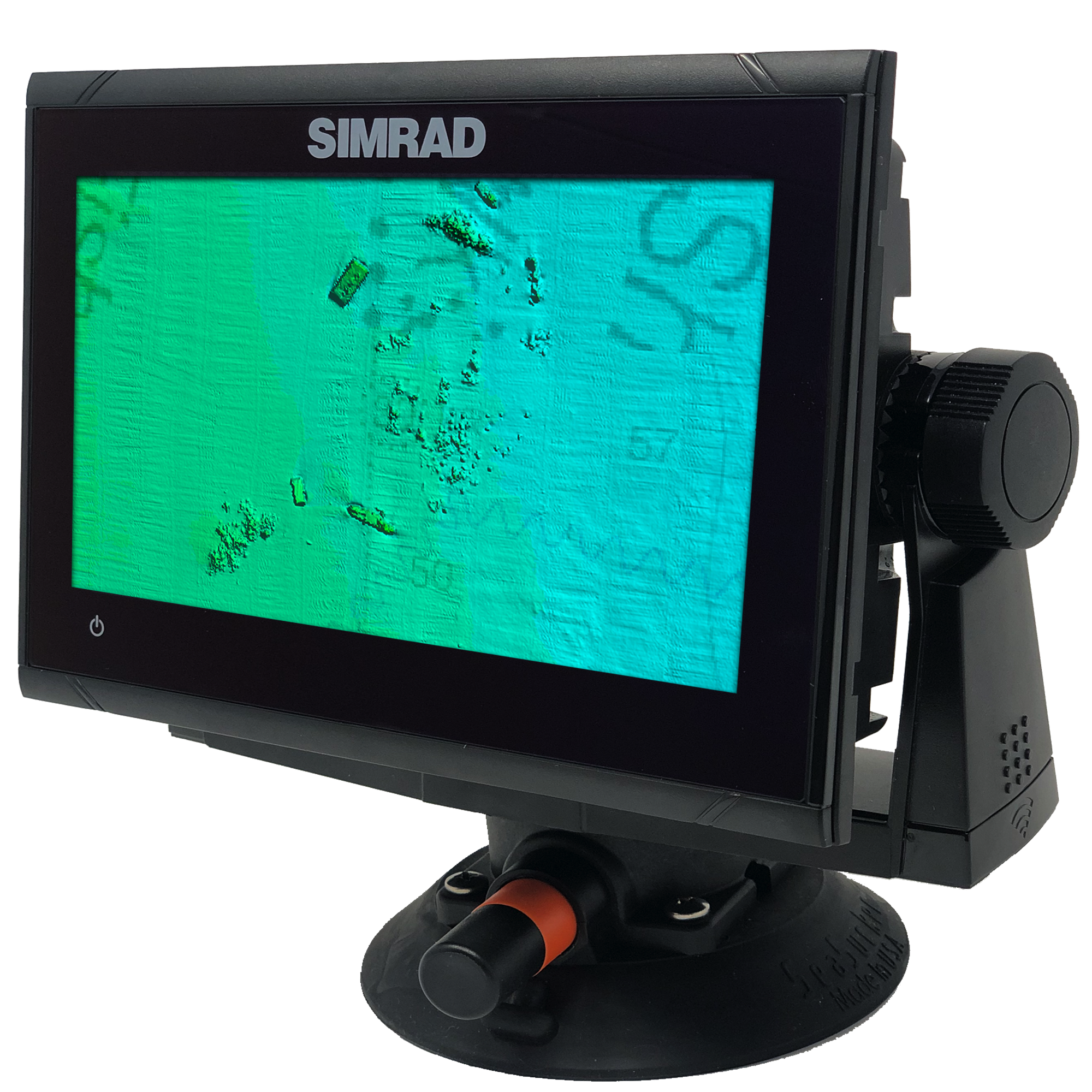
NEX GEN SOUTH ATLANTIC V2 ONLY AVAILABLE ON SIMRAD GO & EVO UNITS AT THIS TIME **********************
Coverage Map
Video Walkthroughs
Compatibility Solutions
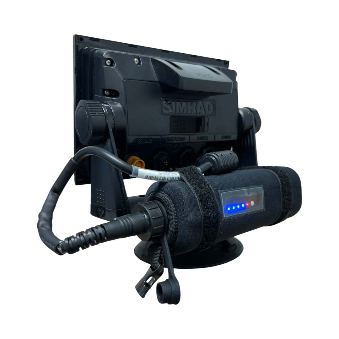
Our CMOR Map Paks include everything you need to use CMOR Cards on any vessel: a Simrad or Raymarine touchscreen chartplotter with built-in antenna, a SeaSucker suction mount, a Marinco 12V plug, a 110V to 12V power adapter, and a custom-fit waterproof hard case.
For Garmin vessels, our Simrad NSO Processor Kit unlocks full touch integration of CMOR Mapping on your GPSMap 8400 or 8600-series unit.


In Stock
FREE delivery next business day within Florida if ordered by 3 p.m. Eastern time. Ships FREE today (details) if ordered in the next:
The New CMOR Nex Gen Features:
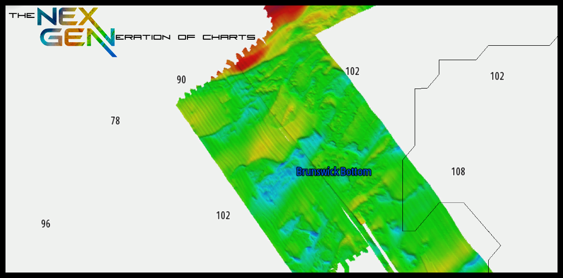
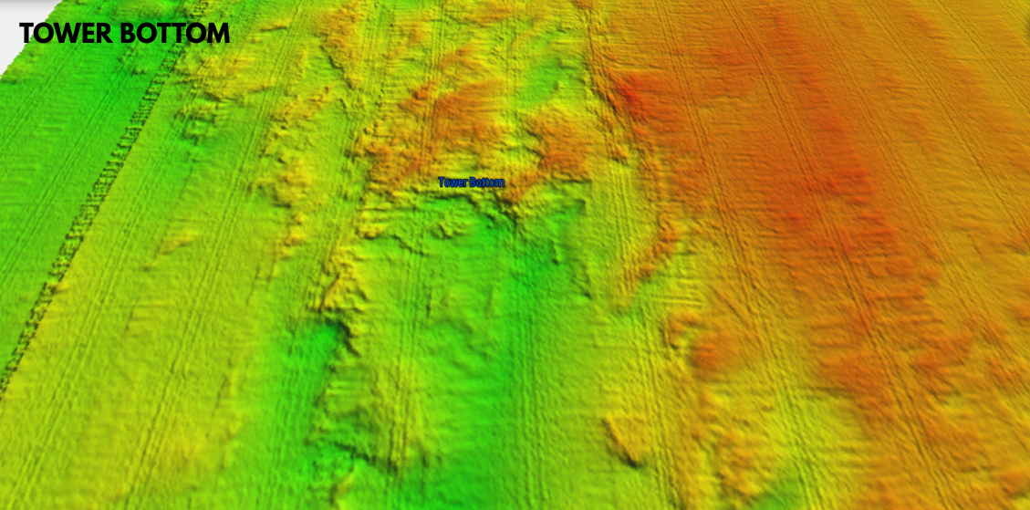
New Ultra-High Resolution Bathymetry
Detailed seafloor imagery revealing subtle ledges, wrecks, rockpiles, humps, and drop-offs with unprecedented clarity.
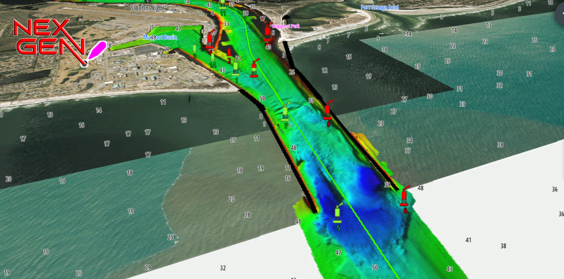
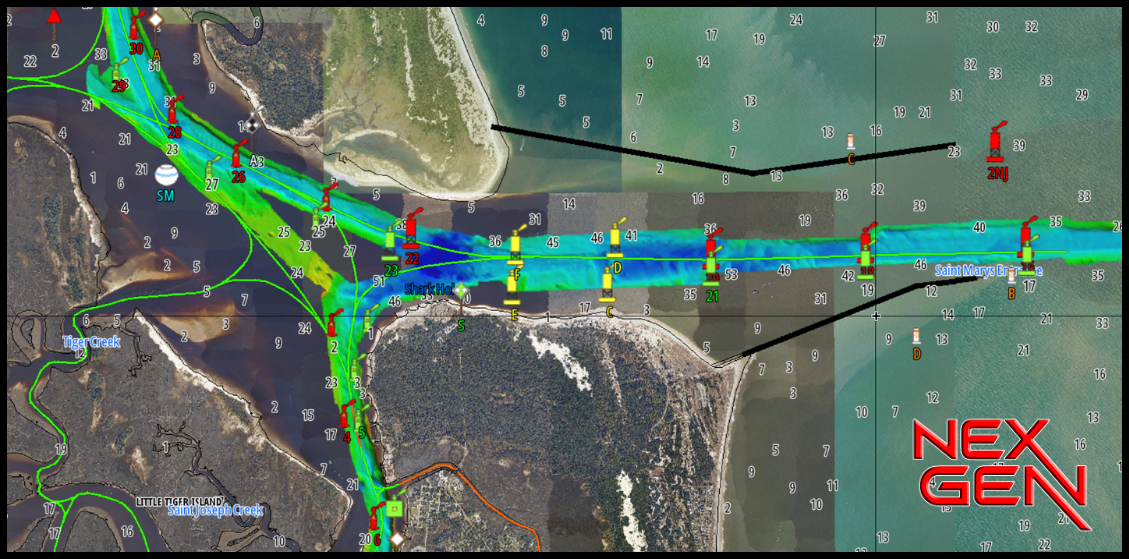
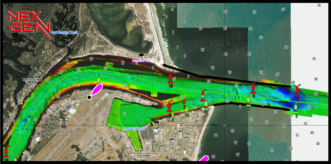
Integrated Navigational Icons & Aids
Seamlessly overlays beacons, buoys, and other standard navigation symbology — safely navigate at a glance. All markers are verified by a real person and are accurate to the inch.
Recommended Speed Routes & Course Planning
Preloaded preferred navigation, suggested approaches to harbors, safe entry/exit channels, and optional routing aids based on depth and hazards.
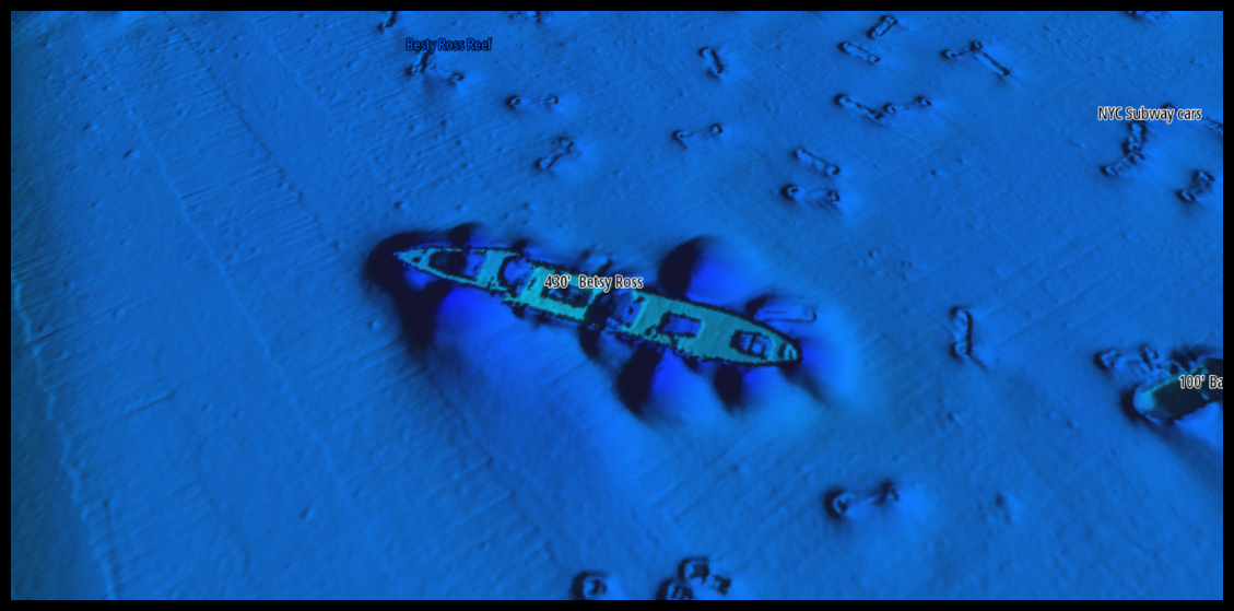
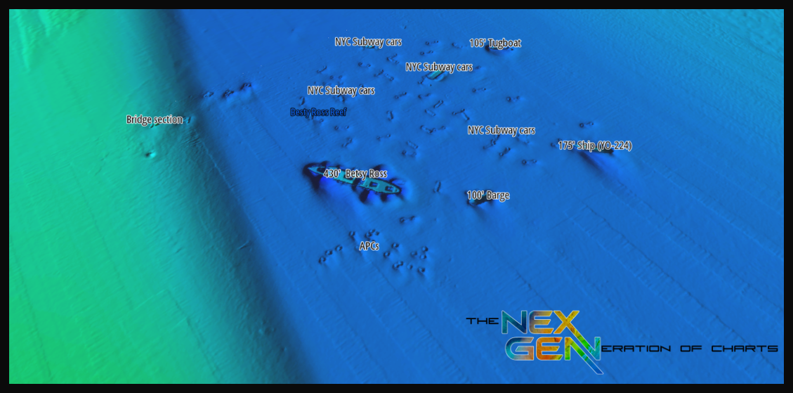
Named Wrecks, Reefs & Submerged Features
Annotated seafloor features with labels — sunken vessels, reef names, rock formations — making it easier to plan drops or dives at recognized structure.
Bridge, Marina & Infrastructure Data
Details on bridges (clearances, timings, spans) and marina layouts (slips, fuel, services).
Aerial Imagery Layer
True-to-life surface imagery of shallow water, coastlines, islands, and structure — providing visual context at a glance. Users can identify shoreline features visually, compare land vs. water, and better orient themselves. All imagery is up to date as of late 2025.
Smart Layering & Zoom-Adaptive Display
Easily toggle between satellite imagery and CMOR relief data — or blend them together — for the perfect view at any zoom level.
All New Contours and Depth Soundings
Fine contour intervals and precise depth data reveal every ridge, channel, and drop-off, giving you a clear picture of the bottom and the structure that holds fish.
Coverage Details
CMOR Mapping bathymetry arms you with more and better data than anybody else on the water.
NOAA Charts are included in the background.
Featured areas include:
100 Fathom Curve (57nm ESE of Georgetown SC)
Charleston Bump and many surrounding areas (swordfish mecca)
Georgetown Hole (47nm SSE Georgetown SC)
100 / 400 area (59nm SE Little River Inlet, SC)
Winyah Scarp (43nm SE Georgetown SC)
“THE LEDGE” (47nm ESE Charleston SC)
River Ledge 75ft depth (18.8nm SE Charleston SC)
Charleston Natural Bottom 41-47ft depth (9nm SE Charleston Harbor)
Charleston Shipping Channel
Deep Drop / Swordfish Bottom 1331 to 1978ft 78nm SE Charleston SC
Edisto Banks (50nm SE Edisto Island, SC)
Southern Edisto Banks (8nm SW of Edisto Banks)
The “DELI” (63nm SE of Hilton Head Island)
Triple Ledge (66nm SE Savannah Georgia )
Grays Reef Ledge 50-60ft depth (18nm SE Sapelo Sound GA)
Natural Ledges Depths 60-65ft (18.5nm ESE St. Chatherines Sound)
Anchor Ledge 75-82ft depth (26nm SE Ossabaw Sound)
“GROUPER” ledges 120-128ft Depth (49nm East St. Simons)
“KBY” Artificial Reef (9nm ENE Fernandina Beach, FL)
SCAMP CITY 140-148ft depth (64nm East St. Mary's River)
“FB” Natural Ledges (14nm ESE Fernandina Beach FL)
Nassau Mud Humps (6nm E Nassau Sound)
Jax Live Bottom 81-86ft deep (17nm E St. Johns River)
Mayport Jetties and St. Johns River
Pinnacles 1450 ft sand – 1351 ft top (43nm E Cape Canaveral)
CMOR Cards are compatible with the following devices:
-
NSS
NSS evo2
NSS evo3
NSS evo3 S
NSE
NSO
NSO evo2
NSO evo3
NSO evo3 S
GO XSE
GO XSR
NSX
NSX ULTRAWIDE
-
HDS PRO series
Elite FS series
HDS LIVE series
HDS Gen1 series
HDS Gen2 series (both keypad and touchscreen)
HDS Gen3 series
HDS Carbon
Elite HDI series
Elite CHIRP series
Elite Ti series
-
502
702
703
903
-
CMOR cards are compatible with all units capable of running the Lighthouse II, Lighthouse 3, Lighthouse 4 and Sport interfaces. In order to support CMOR Mapping, units must have at least v17 software installed. Units include:
Axiom Series
Axiom Pro
Axiom XL
AXIOM 2 PRO RVM
AXIOM 2 PRO S
AXIOM 2 XL
Hybrid Touch
aSeries
cSeries
eSeries
eS Series
gS Series
Dragonfly Series
Element S
ELEMENT HV
-
CMOR imagery is compatible with Furuno NavNet TZtouch2 and TZtouch3 multifunction displays (MFDs) with software version 6.23 or above.CMOR imagery for Furuno is not sold as a physical card. Instead, it is preloaded on your MFD and accessed via an unlock code. After you purchase, you'll need to provide your system ID to CMOR vie email. You will then receive a unique code to unlock the imagery on your MFD.NavNet TZtouch2NavNet TZtouch3TZT2 BlackboxTZT3 BlackboxTZTL12F
TZT14
TZTL15F
TZT9F
TZT12F
TZT16F
TZT19F
TZT22X
TZT24X
-
Full touch integration of CMOR Mapping is possible on Garmin GPSMap 8400, 8600 and 9000 series units with the use of our Simrad NSO EVO2 Processor Kit.
-
Zeus
Zeus Touch
Zeus2
Zeus3
Vulcan