
hydrographic survey
advanced marine technology
Lighthouse Point, Florida, USA- The CMOR Mapping Team consists of industry leading survey and charting personnel with the assets to deliver a comprehensive solution for targeted search and asset recovery as well as hydrographic data collection and processing needs. CMOR Mapping’s high-resolution technology provides a total visual of the seafloor, precise active GPS location, and digitized soundings that have reinvented traditional approaches to analyzing large datasets not only efficiently, but with total accuracy. CMOR Mapping’s elite technology identifies and locates targets on the seafloor with a bottom detect resolution as fine as 3mm, and sounding depth to 400m+, with centimeter level GPS location in realtime via RTK positioning. The CMOR Mapping Team is comprised of the highest rated contributors in our industry, and is outfitted with state of the art technology to deliver an unmatched product with a seamless user experience.
Industry Leading Charts
Taking advantage of new fishing spots just got easier.
CMOR Mapping’s high-resolution, 3D fishing maps unlock a new visual with privately collected data you won’t find on any other chart. Our user experience allows you to simply pre-plan your trips without leaving the dock and then watch your vessel icon move throughout structure on the map using your precise GPS location in realtime as you fish.
How does our team expand private grounds?
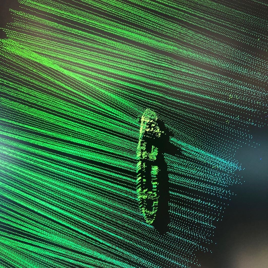
CMOR Mapping’s Survey Fleet is equipped to collect high-resolution, 3D bathymetric data with multibeam technology that is processed by our in house development team. Multibeam Echosounders collect numerous, individual depths (soundings) across a wide, fan-shaped swath of the bottom with every ping produced, that provides a complete bathymetric surface to identify structure and bottom texture with Ultra High Resolution imagery; compared to tradition side scan sonar.
R/V Uncharted

The Pinnacle of Survey Vessels
This multipurpose Research Vessel is designed for quick mobilization, easy configuration for a multitude of projects, and to safely carry out nearshore surveys in water as shallow as 2m, as well as 100 mile offshore multi-day surveys with its increased fuel capacity.
R/V Uncharted’s excellent maneuverability and gyro stabilization provides a platform that can perform efficiently through various sea states and regions while keeping roll to a minimum, providing the cleanest survey data in the industry.
The onboard navigation systems provide state-of-the-art GPS precision and its high speed satellite internet connection allows for quick data uploads or downloading updated objectives while underway.
R/V Uncharted’s apex technology and configuration versatility makes it an ideal vessel for operations seeking data in an extensive range of depths, and is readily mobilized at all times for transport to any location in the US via trailer or loaded on cargo ship for overseas operations
R/V Uncharted is available for charter with captain only or contracted with Cat A Hydrographers who can plan, execute, and deliver any IHO order survey at the highest standard.
-
Dimensions: 40’x12 - 24,000 lbs
Registry: Lighthouse Point, FL, USA
Call Sign: UNCHARTED
Max cruise: 45 knots
Max survey cruise: 12 knots
Propulsion: 2 x 350HP Yamaha
Generator: Diesel Panda 6kw
Fuel Capacity: 400 Gallons
Trailer & Mobilization: Gooseneck trailer for domestic transport, and ship export -
Radar: Garmin
GPS: Dual Garmin / Raymarine Overhead
Autopilot: Furuno integrated with Hypack to autonomously drive survey lines
Rear deck controls
Bow thruster
VHF Radio
Class B AIS -
Two Births
Enclosed head with hot water shower
Fresh water
Air conditioned cabin
Extended deck shade
Microwave
Refrigerator
Starlink high-speed internet -
Sonar: R2 SONIC 2024 Multibeam with custom high speed hydrodynamic pod
Davit: 1500 lbs with electric winch and tow block / cable counter
Sonar mount: Universal sonar mount
Software: hypack, caris, qinertia, qps
IMU: SBG apogee navsight with qinertia post processing
Positioning: Dual Trimble GNSS system
Stabilization: SEAKEEPER 3 gyro stabilizer which removes 90% of roll
Inverter: Clean double sine wave inverter -
Deck space: Ability to mount winches and store / deploy multiple AUV(s) such as gavia
Spacious work deck with extended shaded & AC/DC power connections
Large interior with dual work stations
Gyro vessel stabilization
Fully calibrated multibeam sonar vessel with vessel offsets
CAT A Hydrographers on staff -
CMOR Mapping provides rigorous and consistent testing of all systems to maintain quality datasets with comfortable working conditions.
R/V UNCHARTED is easily configured for a variety of projects from nearshore to overnight offshore missions.
The CMOR Mapping Team ensures that this vessel will undergo all necessary calibration, cleaning, and testing procedures before, during, and after each project.
AUV-Assisted Deep Water Data Collection
Specialized services
CMOR Mapping’s robust experience has brought users ranging from personal vessels to government agencies and private sector companies game-changing charts that have set a new standard throughout the marine industry.
Our mapping services are capable of reaching inshore and offshore areas on a global level with personalized client servicing. The CMOR Team is available to be contracted for an array projects such as Hydrographic Survey, Lidar Bathymetry, Targeted Exploration, Search and Rescue, Underwater Asset Inspection, Hazard Surveys, Burial Assessments, Private Mapping, Cable Route Surveys, Ancillary Services, and more.
Hydrographic Mapping
The CMOR Mapping Team’s ability to develop navigational charts through methodical surveys with state of the art data acquisition technology and processing systems brings a seamless delivery of an exceptional product; ensuring accuracy and detailing above the highest standards in all water depths.
Private Mapping
Whether you’re looking to get the most out of your grounds or explore new areas, The CMOR Mapping Team is capable of delivering a fully functioning chart customized to your needs with top of the line detail.
Lidar Surveying
Lidar Bathymetry provides airborne data acquisition for areas in remote locations and other large data sets that cannot be collected efficiently or with vessel-based methods.
a new visual awaits.
The CMOR Mapping Hydrography Team and R/V UNCHARTED are available for charter.
Please email provide specifications or requests to sales@cmormapping.com.