Identifying structure
with your cmor card

The colors on your CMOR Chart are a useful tool to understand the depth and type of bottom. Red represents the shallowest part of the data set and violets are the deepest. So just like the visible spectrum you can rank the depth by color, ROYGBIV - the black shading is relief.
CMOR Mapping Depth Chart

+ SECTION 1


Section 1 showcases a reef. The orange is the top of the structure (shallowest part by color ranking) and you can see black shading outlining a natural shape, with black spots on top outlining holes. This is a great way to identify a hard bottom.

+ SECTION 2


Section 2 showcases a bottom has a similar look the the reef in section 1 but is more consistent with a yellow/green color. This means it does not have a dramatic change in depth, but looks to share a similar visual to the reef which can be identified as a hard bottom.

+ SECTION 3


Section 3 showcases wrecks. You can see the black shading gradually fades to the north without the presence of black spots like section 1. This appears to be a softer bottom with the current pushing north.


Less time, less Fuel, More Fun 

The best diving and bottom-fishing spots are the ones that don’t show up on the paper or digital charts and aren’t marked on commercially available fishing maps. Instead, they’re the forgotten wrecks, the isolated reefs, the ledges hidden between the contour lines — places you spend hundreds of hours on the water and burn thousands of dollars in fuel to find.

Now, though, CMOR Mapping’s chartplotter-compatible bathymetry reveals those spots for the first time. With resolution as high as 1 meter (each pixel represents a single square meter of bottom) and coverage of the entire bottom, you see every bump in remarkable detail. Just as importantly, you see the areas of featureless underwater desert, where you don’t need to spend your time looking.


Seamlessly Compatible

CMOR Mapping imagery is seamlessly compatible with most Simrad, Lowrance, B&G, and Raymarine chartplotters as well as some Furuno TZT and Mercury VesselView systems. (See our FAQ page for a full list.) Just insert the Micro SD card (SD adapter included) and zoom in on the coverage area to see bathymetry data. Your vessel icon is overlaid on the CMOR data, showing you exactly where you are in relation to bottom features.

All vector data available on your plotter — tides, nav aids, routes, waypoints, etc. — can also be viewed as an overlay ifdesired. In simple terms, a CMOR card essentially adds another layer of extremely valuable data to what you already see on your plotter.

If your chartplotter isn't compatible with CMOR Mapping products, we offer a cost-effective and completely portable solution with our CMOR Map Pak.

The CMOR Map Pak include everything you need to use CMOR Cards on any vessel: a Simrad or Raymarine touchscreen chartplotter with built-in antenna, a SeaSucker suction mount, a Marinco 12V plug, a 110V to 12V power adapter, and a custom-fit waterproof hard case.

For Garmin vessels, our Simrad NSO Processor Kit unlocks full touch integration of CMOR Mapping on your GPSMap 8400 or 8600-series unit.


Complete and Detailed 

Most fishing maps and charts that show depth contour lines interpolate those lines from historical sounding data. In other words, the contours are drawn by looking at the measured depth at a number of points and then making educated guesses about what the bottom looks like between those points. In many cases, the results are fairly accurate. But isolated features — a 5-foot ledge between two soundings a quarter mile apart, for example — are easily missed.

In contrast, CMOR Mapping data is the result of methodical surveys with high-resolution echosounders. There is no interpolation, no guesswork, and no unverified “hotspots” reported by local captains. All you see is a complete, accurate, and highly detailed representation of the bottom, including many features that are not shown on any other chart or fishing map.


A NEW LEVEL OF FOCUS

The value of CMOR Mapping imagery when fishing or diving a new area is obvious — instead of relying on “public numbers” or feeling your way along looking for more productive spots, you’re immediately in the game.

What isn’t so obvious is its value even in your home waters.

Not only will you see features you never knew existed — things you may have run right past a hundred times — but you’ll also see known features in game-changing detail. Large, dispersed artificial reef areas, for example, come into an entirely new level of focus, with each individual piece of structure clearly visible.


CMOR Mapping FAQS

We always welcome questions about CMOR Mapping products, but many of them are answered here. For information about purchasing and shipping, please see our Shipping, etc. page.


WHICH PLOTTERS ARE CMOR CARDS COMPATIBLE WITH?

CMOR cards can be used with many current Simrad, Lowrance, B&G, Raymarine, Mercury VesselView, and Furuno Systems. Compatible units include:

Lowrance

  • HDS Gen1 series

  • HDS Gen2 series (both keypad and touchscreen)

  • HDS Gen3 series

  • HDS Carbon

  • HDS LIVE series

  • Elite HDI series

  • Elite CHIRP series

  • Elite Ti series

Simrad

  • NSS

  • NSS evo2

  • NSS evo3

  • NSE

  • NSO

  • NSO evo2

  • NSO evo3

  • NSO evo3 S

  • GO XSE

  • GO XSR

Mercury VesselView

  • 502

  • 702

  • 703

  • 903

B&G

  • Zeus

  • Zeus Touch

  • Zeus2

  • Zeus3

  • Vulcan

Furuno

  • CMOR imagery is compatible with Furuno NavNet TZtouch2 and TZtouch3 multifunction displays (MFDs) with software version 6.23 or above.

    CMOR imagery for Furuno is not sold as a physical card. Instead, it is preloaded on your MFD and accessed via an unlock code. After you purchase, you'll need to provide your system ID to CMOR vie email. You will then receive a unique code to unlock the imagery on your MFD.

    • NavNet TZtouch2

    • NavNet TZtouch3

    • TZT2 Blackbox

    • TZT3 Blackbox

    • TZTL12F

    • TZT14

    • TZTL15F

    • TZT9F

    • TZT12F

    • TZT16F

    • TZT19F

Raymarine

CMOR cards are compatible with all units capable of running the Lighthouse II, Lighthouse 3, and Sport interfaces. In order to support CMOR Mapping, units must have at least v17 software installed. Units include:

  • Axiom Series

  • Axiom Pro

  • Hydbrid Touch

  • aSeries

  • cSeries

  • eSeries

  • eS Series

  • gS Series

  • Dragonfly Series

  • Element

Please make sure your Raymarine Unit has a micro SD card reader.

For more on using CMOR with your Raymarine device, please watch our instructional video.

Note: CMOR cards are not compatible with RayTech Navigation software, Voyage Planner software, and the following retired Raymarine chartplotting products: G-Series GPM400, E-Series Widescreen MFDs, C-Series Widescreen MFDs, A-Series Classic MFDs, E-Series Classic MFDs, C-Series Classic MFDs, A60/A65, RC435/RC435i, RC400, hsb/hsb2/SL Pathfinder Series Displays, Raychart 320

If your chartplotter isn't compatible with CMOR Mapping products, we offer a cost-effective and completely portable solution based around the Simrad GO7 XSE touchscreen plotter.

How is CMOR imagery delivered for Furuno?

Select CMOR Mapping coverage areas are currently available for Furuno.

The imagery is not sold as a physical card. Instead, it is preloaded on your device or software package and accessed via an unlock code.

Starting in July 2019, all new compatible MFDs will ship with CMOR imagery preloaded. If you have an older NavNet TZtouch2 device, you’ll need to download software version 6.23 or later, which includes CMOR imagery.

After you purchase, you'll need to provide your System ID to CMOR vie email. Your System ID can be found under the MyNavNet menu on your device. You will then receive a unique code within 1 to 2 days to unlock the imagery on your MFD.

How much detail does the data show?

Resolution is as sharp as 1 meter in shallow areas and is slightly reduced as water depth increases. That means each pixel can represents a single square meter of bottom in the shallow water.

How accurate is the data?

CMOR bathymetry is based exclusively on full-coverage surveys of the bottom with high-resolution echosounding equipment. There is zero guesswork involved. In fact, if you compare CMOR imagery to other representations of the seafloor — particularly fishing maps — you'll be surprised by how inaccurate they are.

Does CMOR imagery show bottom features other charts and fishing maps don't?

Yes, a lot of them. Other representations of the seafloor are largely interpolated from scattered soundings and augmented with anecdotal information about the location of additional features. Our imagery shows every bump.

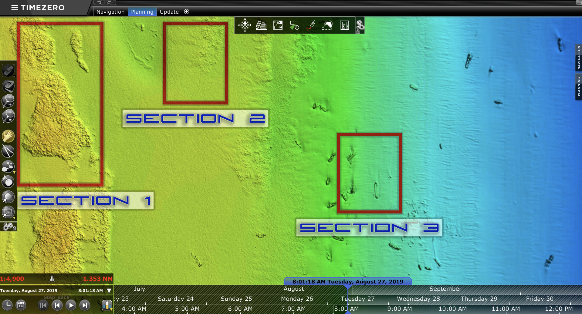
What do the colors represent?

Depth is represented by color. Reds are the shallowest, purples and magentas the deepest.

Will the CMOR Card wipe all of the user routes and data stored on my unit?

No. Your user data will still be accessible and will run on top of CMOR imagery. However, it is always advisable to back up all of your user data on an extra SD card.

Are you going to offer cards for other plotter brands?

At this time, CMOR Mapping is a licensed mapping partner of Navico, which manufactures Simrad, Lowrance, and B&G, Raymarine, Furuno, and Mercury VesselView.

If your chartplotter isn't compatible with CMOR Mapping products, we offer a cost-effective and completely portable solution with the CMOR Map Pak. The CMOR Map Pak is a standalone GPS chartplotter with a SeaSucker mount, powered by 12v cigarette lighter outlet, has an adapter for use at home, and a weatherproof case. The CMOR Map Pak is available as a 7” or 9” display. This will give you the ability to bring CMOR Mapping on any boat, as well as the power to plan trips from home.

Can I copy the data to my computer or another card?

No. CMOR Cards are encrypted. If you copy the contents to another card or a computer, the data will be unusable. You will also lose functionality if you rename, move, or delete any of the files from your CMOR Card. CMOR Mapping recommends that you do not add any additional files on the card either.

When a CMOR Card is updated, do current owners get a discount?

Yes. We occasionally expand the coverage area of existing cards. When we do, we notify owners of the previous version by email. If you purchased the previous version in the last 60 days before the update, we will be happy to swap it for the updated version at no charge. (Proof of purchase with date is required unless the card was purchased through this site.) Otherwise, a fee of $150 applies to help offset processing and licensing costs.

To order an update, visit our Updates page and order your new card. When you place your order, ship your old card to CMOR Mapping, 4640 N Federal Hwy, Lighthouse Point, FL 33064. Use a shipping service with tracking. Once we receive it, we'll ship you the new one. If you purchased the previous version within 60 days of the release of the new version, email us for instructions on upgrading.

Where can I get help with my CMOR card?

Contact us at sales@cmormapping.com or 813.563.CMOR. We'll be happy to help.

ARE CMOR CARDS SUITABLE FOR NAVIGATION?

No, we ask that you do not rely on CMOR data for navigational purposes. Although we're confident in its accuracy, it is intended only to show the seafloor and does not include other important information for skippers.

WHEN WILL YOU OFFER A CMOR CARD FOR MY AREA?

As soon as we possibly can. Gathering the data to create a new coverage area is time consuming, but we're excited to expand our coverage. Please let us know what areas you'd like us to focus on by filling out our 30-second survey.

WHAT SIZE IS THE CMOR CARD?

All cards except imagery for Furuno/TIMEZERO ship as a Micro SD and come with a regular SD adapter. Furuno imagery is preloaded on compatible devices and can be accessed with an unlock code that we will send you.

DO I HAVE TO LEAVE THE CARD IN THE UNIT FOR IT TO OPERATE?

Yes.

DOES THE SD CARD NEED TO BE INSERTED INTO THE ADAPTOR?

Yes. If you are using a machine that uses an adaptor, be sure to have the micro sd card inserted into the adaptor first and then insert the combo into your machine. 

CAN CMOR BE TAKEN FROM BOAT TO BOAT?

Yes. You can easily eject your CMOR card and take it with you from boat to boat. CMOR does not download to your machine so all the data is saved to your card. 

HOW DO I INSTALL MY CARD?

Simrad installation

Raymarine Installation

Printable Installation Instructions